Norway to Portugal Part 3: Oktoberfest

Expectations

Honestly, I went into Oktoberfest with mediocre expectations. I've been to a decent amount of festival type events. A festival all about beer seemed like it might lack variety.

Another worry I had was that it would be very touristy. Oktoberfest is extremely well known across the world. I thought that fact might have caused it to become overrun with tourists and lose it's roots.

oktoberfest.jpg

 History

Oktoberfest originally started in 1810 as a royal wedding celebration. It has since then transformed into a Volksfest (folk festival) celebrating Bavarian culture. This, of course, includes beer.

I think my favorite fun fact is that the festival has been held at the same grounds for the entire 200+ years of the festival's existence. The grounds, known as Theresienwiese (Theresa's meadows) or simply the Wiesn (fair grounds).

The beer sold at Munich's Oktoberfest is made specifically for the event and must conform to Reinheitsgebot or the "German Purity Law" which limits the ingredients that can be used in brewing. This law originally pertained to all beer made in Germany and was created in part to keep the beer "pure". Oddly enough the "Oktoberfest beer" is also stronger than normal beer. It also must be brewed within the city limits of Munich.

One cool part about this law is drinking beer that has cultural significance and tradition behind it. The downside is that there is almost no variety in the beer you can drink at Oktoberfest. You really are just drinking this one kind of beer despite visiting the many different breweries. This is in contrast to a craft beer festival where you could taste dozens of vastly different styles and flavors of beer. 

The Festival

OlinShai.gif

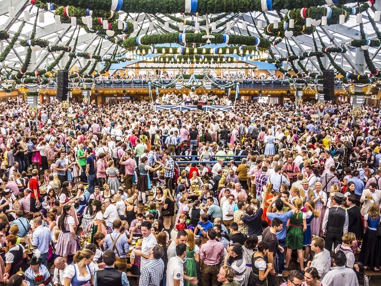
The festival grounds is over 100 acres. Half the grounds feel like a carnival with rides, games, and food. The other half is where each of the major breweries has a tent for you to drink and eat in.

oktoberfest_grounds.jpg

The word 'tent' doesn't quite do these buildings justice. They are built and taken down every year but that is hard to believe when you see them. Each one is a giant warehouse that fits thousands of people inside with seating for a couple more thousand on the outside.

Each tent is operated by a different brewery in Munich such as Hofbrau, Augustiner, Spatenbrau, and Paulaner. The insides actually don't differ that much. Each one has many long tables and a stage with a band. Music before 6:00pm is limited to acoustic and brass instruments. This is to keep the traditional atmosphere and to be welcoming to the elderly and families during the day time.

InsideTent.png

Going inside one of the tents can be a little daunting at first. Some tables are for reservation only while others are first come first served. If you come to Oktoberfest with any more than 4 or 5 people. Reserving a table is probably in your best interest. Since it was just Shai, Colin, and I, it was easy to join a non-reservation communal table with just 3 people. You either find a table yourself or a waitress will squeeze you in with another party.

This was actually my favorite part. We made friends with everyone we sat next to. It was a very open and friendly environment. We met all kinds of people from locals to other Europeans and of course other Americans.

This was one of my expectations that ended up not being true. I did not get a sense that I was just surrounded by tourists. The majority of the Oktoberfest population was, in fact, German.

A stereotype that did hold true were the waitresses. They pretty much look exactly like in this photo:

oktoberfestwaitress.jpg

They wear the traditional Bavarian dress and can carry 5 liters of beer in each hand! It was actually quite impressive.

Other than talking to our neighbors, the next most common activity was singing and dancing. The bands play some traditional music but the majority are classic (mostly american) sing-a-long hits that everyone knows including Sweet Caroline, Take Me Home Country Roads, Hey Baby, We Are The Champions, Don't Stop Believin, just to name a few.

Sweet Caroline

Hey Baby

 Don't Stop Believin

We are the champions

It's common, almost mandatory, to stand on the table to sing, dance, and cheer. Later in the night, no one is left sitting.

Another song, well it's literally a toast, that plays every 30 minutes or so is Ein Prosit. Which translates to "A toast". The full song is just repeating a few lines that go:

A toast, a toast

To cheer and good times

A toast, a toast

To cheer and good times

One! Two! Three! Drink up!

And yes, there is lots of drinking. People are constantly doing cheers with each other which has a domino effect with everyone else at the table. 

Cheers1.gif

While we're on the topic of drinking. Not only is everyone drinking the Oktoberfest beer, everyone is drinking out of liter steins. To clarify the math, a liter is 32oz or just shy of 3 cans of beer.

ColinCheers.gif

Food is also plentiful at Oktoberfest. Each tent has a full menu of traditional Bavarian grub. For a cheaper option, you can eat at the stalls outside.

And of course there are plenty of bathrooms. So, yes, it is possible to stay at one tent the entire day of Oktoberfest.

Conclusion

Overall I loved the atmosphere that Oktoberfest cultivates. Everyone is so open and kind and just there to be have fun and be happy. You also get exposed to German culture through the food, drink, people, and music. 

So, who wants to go with me next year?

Shout out to Colin and Shai for the unforgettable experience!

GroupPic.jpg

Norway to Portugal Part 2: Lysefjord

I just spent 3 days hiking in Lysefjord. It is a (relatively) small fjord in the southern part of Norway near the city of Stavanger (Sta-vung-er, not pronounced like the word “scavanger”).

The combination of seeing the fjords by hiking and from a boat made for an incredible adventure.

Below is a chronological account of my journey littered with pictures, maps, and videos. Hopefully in this way, I am able to show you the beautiful landscape that Norway is blessed with.

I’m just going to throw this video up at the top since some of you won’t make it all the way to the bottom of this post. However, it probably makes sense to watch it after you finish reading.

On Monday I took a ferry from Bergen to Stavanger. The journey was 5.5 hours on a cruise line that goes through several islands off the coast of Norway.

Ferry Route

Ferry Route

I use these long travel times to get some work done.

Discover & share this Waves GIF with everyone you know. GIPHY is how you search, share, discover, and create GIFs.

I stayed in a private room from Airbnb for the night. Airbnb has been the cheapest and most convenient way to get a nights rest here in Norway.

I wondered around the small downtown area of Stavanger and met up with my German friend, Alexander, whom I met at my Airbnb in Bergen. We stumbled into a bar that had over 100 beers! That sounds great until you find out that the minimum price was $10 USD per beer.

The next morning I took a ferry from Stavanger to Tau and then from Tau I took a bus to the trailhead of Preikestolen (Pulpit Rock).

The trail was just over 2 miles and consisted of a series of climbs and flat areas. Lots of rock stairs up hills and wooden planks through marshes. By the end I was above the tree line and hiking on open rock.

Olin_Lysefjord.jpg

Near the end of the hike I came to the edge of a cliff that drops off into Lysefjord.

Good1.jpg

I hugged the cliff face for another 100 meters until finally arriving at pulpit rock! This is truly an amazing natural formation. Like a giant rectangle jutting out from the cliff. It stands 600 meters above the fjord.

Good7.jpg

There were dozens of tourists by the time I got here around 11:30am. Everyone waiting their turn to take a picture on the edge. The top of the rock is probably 20m by 20m, so lots of space.

_Me6.png

I got up a little higher where there was a better view of the rock formation above the fjord.

Good5.jpg
Good6.jpg

There was a peak to the right of pulpit rock with plenty of space to sit, eat lunch and enjoy the view.

G0030153.JPG

After almost 3 hours I decided it was time to head back. There was a mountain I wanted to hike that had a 360 view of the area. Unfortunately my right knee was starting to bug me. I’ve learned to listen to my body when it’s telling me to stop. I also knew the next day was going to be a long one and I wanted to be well rested.

I got back to the lodge/hostel and checked in. This lodge overlooks a lake with rentable kayaks, paddle boards, etc.

Cabin2.jpg

I decided to eat dinner and get some work done. I was able to sit here and do work as I saw a storm roll in.

Work1.jpg

I slept in the dorm building they had. Complete with bathrooms, showers, and a kitchen. My bed was in one of the 2 bunk rooms which had 11 beds. Tonight there was only 1 other person. He was a lovely gentleman by the name of Kelvin! He is a retired teacher from Hawaii who had some impressive magic tricks to show me.

In the morning we ate at the included breakfast buffet and then parted ways.

There were a couple hikes I could do on this day. I could hike that mountain that I passed the day before or I could go the opposite direction and go to a different spot against the fjord that, quoting a worker from the lodge, “has a similar view of the fjord without the crowds”. Instead I decided to hike a trail along the fjord for a few hours and then turnaround to catch the ferry back to Stavanger from Tau.

First, it’s worth noting that the trail starts about halfway down the Preikestolen trail. I actually missed the trail head and by the time I realized it, I just continued all the way to Preikestolen. Since I got an earlier start, there were less people. It was a different experience because the sun was in a different location and there were clouds.

Discover & share this Timelapse GIF with everyone you know. GIPHY is how you search, share, discover, and create GIFs.

For views of landscapes I actually prefer partly cloudy over clear sky. Below you can see an example of what I mean.

Preikestolen_Comparison_small.png

Bonus picture I got this day.

_Me11.jpg

I turned around and found the trail I was originally aiming for. This trail was much different than the one to Preikestolen. The trail starts descending into a valley with a sign saying “STOP you are no longer on the trail to Preikestolen”. The trail is basically a stream down into a valley. I had to hop from rock to rock avoiding puddles. This was the point I realized that water proof hiking boots would have been really nice.

Hiking3.jpg

It was about 1 hour hiking down this valley that I realized I would have to hike back UP this valley. That didn’t sound too appealing to me.

That’s when I asked the question “what if I just didn’t turn around?”

I did a check of what stuff I had on me:

  • Food for multiple days

  • 3 water bottles (and you can refill in streams here)

  • Rain gear (except water proof boots, whoops)

  • A map

  • GPS working on my phone

  • Portable battery for my phone

What I didn’t have was a sleeping bag or tent. So I knew I had to make it to a hostel.

The worker at Preikestolen lodge told me there was a ferry out of Songesand which was about a 6 hour hike. I also knew that there was lodging in that area in case I didn’t make the ferry. So that destination became my goal.

The hike was wonderful. I love getting away from tourists and just being alone out in nature. It’s worth noting that I was very confident about finding my way around. The map and GPS were very useful and I had phone service when I was high up. The one thing I had to be very careful about was not getting hurt. This is true at all times when hiking but especially so when you are alone because there is no one to send for help (112 is the emergency number in Norway).

Another way to not get lost is to always follow the trail markers. They are designated with a red ‘T’ and are very frequent.

Trail1.jpg

The descent into the valley was only the first part of the hike. I quickly came to another peak which had amazing views of the fjord but without the tourists!

The hike continued in and out of the trees, against the fjord and also inland.

Discover & share this Timelapse GIF with everyone you know. GIPHY is how you search, share, discover, and create GIFs.

One of my favorite parts was hiking against a ridge that was right on the fjord. Good views down either side.

Looking left

Looking left

Looking right

Looking right

There were a couple hard parts of the hike. Multiple river/stream crossings where I had to try 3 or 4 different spots to get across. Again, these might have been easier with waterproof boots.

As well as parts where you have to hold onto a chain to climb/shimmy your way across some rocks.

Hiking1.jpg

I was getting quite exhausted and the weather was starting to turn on me.

The hike to this point was 11 miles over almost 10 total hours. This includes the detour to Preikestolen, a couple trail blazing excursions, and getting utterly exhausted by the end and having to stop frequently. I was actually moving for about 6 hours.

Using the Den Norske Turistforening (DNT) app, I showed up to a cabin in Bakken to get some sleep.

There were a limited number of beds that can be reserved. Over half of the beds are meant to be first come first served, which is what I relied on.

The cabin was also more well stocked than I anticipated. I expected a roof over my head and maybe a mattress. This cabin had a gas stove with plenty of fuel, kitchen supplies, beds, linens, pillows, and of course an out house! Water could be retrieved from the nearest stream.

The cabin is maintained by the people in the surrounding village community.

There was actually a locked house that could be reserved ahead of time. The cabin I stayed in was referred to as the “barn”. There is no lock and you keep the door closed with a rock.

The white building is the “house” and the wood and rocks on the right is the “barn”.

The hostel at Preikestolen had a fraction of it’s fill capacity. I thought I would be lucky to see one other person at a cabin like this one. Unfortunately for me, there was a group of 10 people from Holland that took over the entire cabin.

They initially told me I could stay in the stable out back. Yes, I couldn’t get into the house or barn, so I planned on sleeping in the stable and curling up in the hay where they originally kept the sheep.

Left building is the “barn”. Back right is the “stable”.

Cabin5.jpg

I actually imagined worse scenarios for how the night could end up so I knew I could tough it out for just one evening. Of course, I wasn’t going to sit alone in the dark stable twiddling my thumbs, so I stayed in the barn to socialize with my new Dutch friends.

After getting to know them for a bit, they seemed to loosen up with me. They eventually shifted people around and gave me one of the beds. They were also cooking burgers and fries and invited me to join!

Quite the turn of events. I went from sleeping in the sheep stable to getting a hot meal and a bed.

In the morning, I decided to do some research on this ferry that ran out of Songesand. I’m glad there was service (sometimes) because there is only 1 ferry per day (well it goes down the fjord and back so 2 possible pick ups) and it won’t stop at certain docks if no one books the ferry in advance. I booked my trip and headed to get picked up.

Here is the Strava from this portion of the hike, I stopped it about a mile in and forgot to restart it. But I want to show the pace I was going. Even after a nights rest, I was going pretty slow. 25:36/mi first mile the day before versus 35:05/mi this day. This was due to the trail difficulty. Half the time I was hopping from wet rock to wet rock.

This hike was along the coast, much closer to the water than the previous day.

I finally arrived at the dock with a couple hours to spare. There was a waiting area where I got some work done.

Ferry2.png

Turns out there is a “Songesand Camp and Café” here which has 9 beds for sleeping in addition to tent and RV camping. So this would have been a more traditional hostel situation if I had made it this far.

The ferry picked me up and we went to Lysebotn which is a town at the very end of the fjord. Then I just stayed on and rode the ferry all the way back out of the Fjord to a town called Lauvvik where I was able to get a bus back to Stavanger.

Ferry5.jpg

Seeing this fjord by ferry was amazing. I was able to see the places I hiked the days before. The fjord is pretty narrow, so you really get a good view of either side no matter where you are on the water.

Ferry6.jpg

Being on the water with the steep mountains and cliffs on either side was staggering. The fjord extends as far as you can see.

Waterfalls and picturesque villages line the sides. I felt like I was in a King Kong movie or somewhere in middle earth.

Ferry10.jpg
Ferry8.jpg

Here is a map of my total journey around the Stavanger area.

Lysefjord_Map.png

Here is some advice if you have ever thought of visiting Norway.

All in all I would say the fjords are an adventure absolutely worth experiencing, both by foot and by boat. Just be prepared for a good hike and wet weather. The trails are unforgiving but the views are absolutely worth it.

Also, if at all possible, come when the weather is good. Doing these hikes in the rain and wind would have been rough. The summer is the obvious choice but even then it still rains. I was fortunate enough to have the flexibility to choose the timing of these hikes for when the weather was going to be good (thank you 10 day forecast). You can’t even do these hikes November-April because of the snow. Some trails are open to snowshoe or cross country skiing.

Thanks again for reading my blog! I find it the best way to convey my thoughts and to transfer information from my brain to yours. The written word in combination with photos, gifs, and videos is better able to capture some of the emotions and highlights of the trip.

At the end of this post is a list of resources for such things as ferry, bus, and trail info.

Until next time!

Resources

Bergen to Stavanger ferry: https://www.fjordline.com/nb/p/ruter/bergen-stavanger-innenriks

Stavanger to Tau ferry: https://www.fjordnorway.com/planning-your-trip/getting-to-and-around/transport/ferry-stavanger-tau-p1437073

Hiking trails: https://www.komoot.com (I also bought a map at the Preikestolen lodge)

Lysefjord year around ferry: https://www.kolumbus.no/globalassets/ruter/baatruter/stavanger-lysebotn-kombibat.pdf

Lysefjord tourist cruise Jan-Sep: https://thefjords.no/files/documents/fjord-cruise-lysefjord-2018.pdf

#47 bus between Lauvvik and Sandnes: https://www.kolumbus.no/globalassets/ruter/bussruter/stavanger-sandnes-omegn/47-sandnes-sviland-lauvvik.pdf (I had to wait 2 hours between the Lysefjord ferry and this bus)

#2 bus between Sandnes and Stavanger is pretty frequent and using the Skyss app to pay for #47 should give you free transfer to the #2. You can also take the light rail from this area.

Norway to Portugal Part 1: Why Norway, Packing List, and My First Hike

I have arrived and settled in Bergen, Norway as my first “digital nomad” location. I’d like to share some of my latest thoughts and experiences.

View from an old Bergen fort

View from an old Bergen fort

First, here is a timeline of where I will be these next 2 months.

Sep 6 — Oct 2: Bergen, Norway

Oct 2 — Oct 4: Munich, Germany

Oct 4 — Oct 31: Lisbon, Portugal

Why Norway?

The most common question I get is “why Norway?” I think that there are many great places in the world to visit and you don’t really need a reason to go anywhere. None the less, here are some reasons why I chose Bergen.

Reason #1 is hiking. The west coast of Norway is home to world famous fjords. Fjords are remnants of glaciers that left inlets with cliffs or steep mountains on the sides. I haven’t yet gone outside of Bergen, but I plan to see the fjords by both hiking and boat.

Reason #2 is that Bergen is off the beaten path. During my travels I have learned that my favorite places are those where there are the least amount of tourists. This place has a very small town, local vibe. Living here for an extended period of time is one of the best ways to get that experience.

Reason #3 is that people here speak very good English. Sure, that’s true in a lot of places, but if you’ve ever talked to a Scandinavian, you know what I mean.

Reason #4 is that the people here are tall. It’s nice.

Reason #5 is that I might have Scandinavian accentors? My name, Olin, comes from my great grandfathers brother, Olin, who died at 19 due to appendicitis. Before that, I don’t know where the name came from. In Old Norse, the name means “ancestor’s heir” (a humble meaning, I have to say). Old Norse was mainly spoken by those living in Scandinavia in the 9th through 13th centuries. However, the language was also spoken in Great Britain which is where the Olmstead side of my family traces our heritage back to.

Packing List

I want to take a step back and look at what I brought with me on this trip. I find it interesting to see what people bring on long backpacking trips. I like looking at packing lists online to find useful items and tips on how to condense baggage as much as possible.

So, whether you find it interesting or not, below are my itemized belongings. I added notes where I thought I should expand on certain items. This is also a reference for my future self 😃.

Clothing Bag

Clothing

Clothing

  1. 8 Pairs socks

  2. 8 Pairs underwear — Yes, I may be wearing a pair of underwear/socks more than 1 day 😮

  3. Seahawk quarter zip — Go Hawks

  4. Short sleeve collard shirt

  5. Long sleeve collard shirt — In case I need something fancy

  6. Fleece — A core item to layer with for cold weather

  7. Shell/Rain coat/Wind breaker

  8. 3 T-shirts

  9. 3 Long sleeve shirts

  10. Workout shirt

  11. 2 Tank tops

  12. Pants — I use one pair of pants that are great for hiking, going out, doing anything basically. They are quick drying, water resistant, stretchy, durable, and “stylish” (aka don’t look like traditional hiking pants but use the same materials)

  13. Shorts

  14. Basketball shorts

  15. Swim trunks

  16. Running shoes — Hoka Mach for those wondering

  17. Hiking boots — Merrell’s that have held up since I was in high school

  18. Sneakers

  19. Tortuga “City Backpacking” Backpack — I highly recommend this style of backpackif you are not needing any features of a traditional hiking backpack. For example, this opens like a suitcase instead of top down only. Great if you are just staying in cities and not doing any camping while abroad.

Day Pack

Everything else

Everything else

  1. Duct Tape — a small amount wrapped around a business card

  2. Twine

  3. Pen, pencil, extra lead, eraser

  4. Chapstick

  5. Tide-To-Go pen

  6. Flash drive

  7. HDMI to lightning cable

  8. Mints

  9. Business cards

  10. Luggage lock — for traveling through airports or locking lockers in hostels

  11. Bluetooth headphones

  12. Micro USB cable x2

  13. USB-C cable x2

  14. iPhone/iPad cable

  15. Mouse and mouse pad

  16. Portable chargers — one big and one pocket sized

  17. iPhone — for testing games

  18. Deck of cards

  19. Sun glasses

  20. Sticky notes

  21. Power converter and mini power strip

  22. Deodorant

  23. Go pro and accessories

  24. Go pro tripod

  25. Portable speaker

  26. Kindle

  27. Workout bands — still gotta workout!

  28. Lacrosse ball — for rolling muscles

  29. Knee sleeves

  30. Beanie

  31. Toiletries — toothbrush, toothpaste, floss, nail cutter

  32. String bag

  33. Chromecast

  34. First Aid Kit

  35. Headphones

  36. Extra Ziploc baggies — they always come in handy

  37. Water bottle

  38. Copy of passport — helps get you a new one if yours gets lost/stolen while abroad

  39. Inflatable neck pillow, eye mask, ear plugs

  40. Laptop charger

  41. Laptop

  42. Notebook — with dot paper

  43. iPad — for testing games

  44. Backpack — Patagonia brand

Not pictured:

  1. Supplements like vitamin C & zinc for preventing illness (ie. immune support), creatine for fitness, caffeine pills (cheaper than coffee and helps fight jet lag), generic version of Benadryl (used mostly as a sleeping aid to fight jet lag).

  2. Phone, wallet, keys, passport

  3. Myself

I’d like to elaborate on how I successfully fight jet lag because I hear other people who struggle a lot with it. When I arrive in a new time zone, at all costs I will sleep during the normal sleeping time of the new time zone. If I have to stay up when it’s normally my bed time, then I stay up and use caffeine if need be. If I have to force myself to sleep when it would normally be the middle of the day, then I take some sleeping aids and try to make myself tired by limiting sleep during travel.

Ok, if talking about jet lag was a little boring I’ll end with a beautiful hike I did in Bergen.

Hiking

Walking distance from my Airbnb is the Bergen mountain hiking area. It’s a HUGE area that will take me multiple day trips to fully explore.

BergenMap.png

The trail I used had a steep climb. Not the casual hike I was expecting. However, climbing up rocks next to waterfalls was pretty nice.

IMG_20180907_114809592.jpg

Once I got to the first ridge things got a lot easier. There was a large area with lakes and flat trails. There were many more people up here that must have used the switchbacks near Floyen.

IMG_20180907_121301272.jpg

I then went up a little further and got above the tree-line to a beautiful ridge that might be called Kvitebjørnen. The trail kind of disappears as you hop from rock to rock. Sculptures built on peaks guide your way. It was a bit windy here but I got to see a good view of the water, towns and inland mountains.

IMG_20180907_131207027.jpg

I walked past a couple cabins that are available for campers. I also overheard that these can be used in emergencies. The weather can take a turn for the worst very fast and these are places for shelter and contain emergency supplies.

IMG_20180907_140501551.jpg

Oh yeah and I’m working! My room at the airbnb is very spacious with a desk and view of the water. I have been splitting time between there and going out to coffee shops to work.

Room in Airbnb

Room in Airbnb

View from my room

View from my room

It has been quite rainy here, luckily I’m used to it 😝 . Hopefully the rain clears and I can do some more extended hikes.

So that’s what I’m up to. Until next time, cheers!

IMG_20180907_141254960.jpg